A sound shell for performances and movies, pathways and a bridge are part of the work underway at City Park in Hervey Bay. The project, being undertaken by the Fraser Coast Regional Council, is part of the City Park Master Plan which aims to activate the area in the centre of the city between the Fraser Coast Cultural Centre and the Hervey Bay Community Centre.
Work so far has included moving a shelter from the southern side of the park to be in front of the Hervey Bay Community Centre. The existing concrete slab on the southern side of the lake will be re-used as part of a sound stage. Earthworks have been undertaken to create a grassed amphitheatre to improve the audience view of performances on the stage. Pathways are being built to link the cultural centre with the sound stage, an existing toilet block, the Link Mobility Corridor as well as to a 22-metre bridge which spans the lake.
"The project will improve use of the area", Events and Recreation Portfolio Councillor Darren Everard said.
"A range of events from the Condy Park Preschool Teddy Bear's Picnic to the Rotary Club of Hervey Bay Sunrise Tour De Bay are held in the park now. These works will enable more events to be staged in the parkland as well as catering for the school excursions visiting the Fraser Coast Cultural Centre and Discovery Sphere."
Future works include a viewing platform and shade structure over the entrance to City Park from the intersection of Main Street and Torquay Road.
"The works will ensure that the CBD continues to attract people and events," Youth and City Precinct Development Portfolio Councillor Daniel Sanderson said. "As the population grows there is a demand for places for groups to organise small events other than our already busy foreshore parks." Most of the work should be completed by late June 2017.
Usually, I write these articles, but Kevin Corcoran from the Fraser Coast Council wrote the above summary so succinctly, that I hardly needed to add any words. My own university education is a degree from the University of the Sunshine Coast in Property Economics and Development.
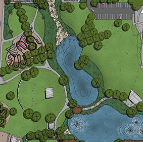
This City Park development is of fundamental importance in the progress of this sized regional city, and a timely upgrade for the old retention basin. For decades it will be the central recreation and cultural precinct providing the growing local population with a place of identity equal to the great parks within the Central Business Districts of the state capitals.
From 2011 to 2036 Hervey Bay is predicted to increase from 52,838 residents to 102,621. The Sports Park at Nikenbah, when developed quite a few years into the future, will complement the Pialba City Park. Map 33 has some City Park features, but in the smaller detail appropriate to the scale of that map.
Below is an explanation of the numbers on the council plan, which they have allowed us to reproduce on our front cover. We have oriented the plan almost due north (about 8° off), so that when you park N-S in the main carpark off Charles St, or if you stand in Old Maryborough Rd, you can hold the Pocket Book in front of you to easily pick out the direction to the features of the park.
Regards,
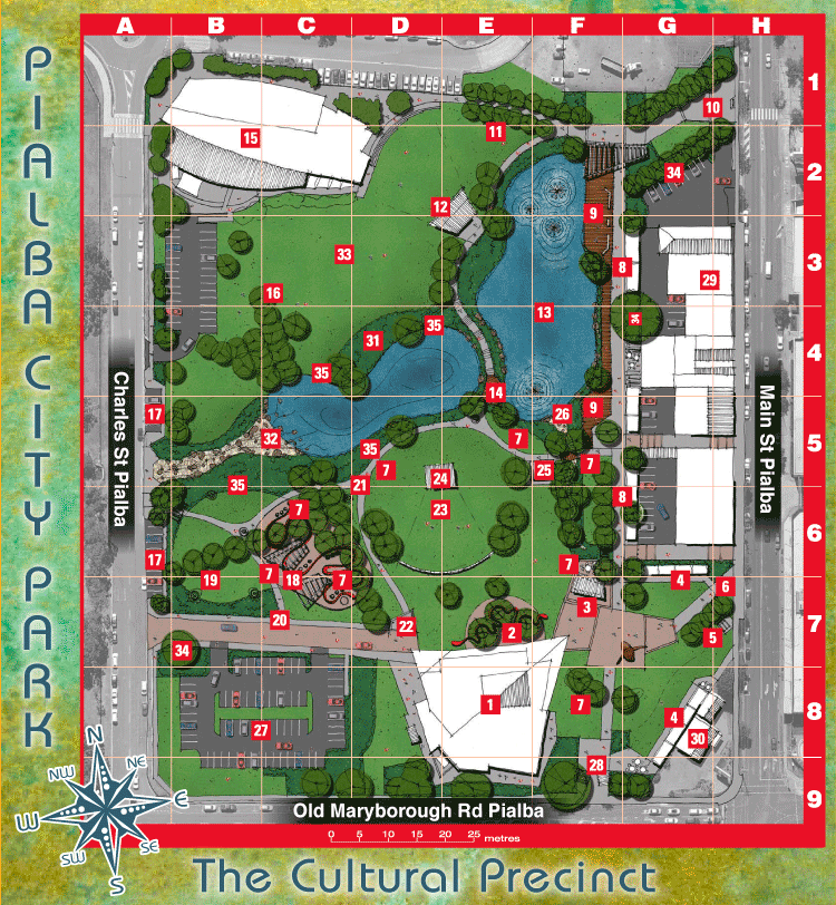
(1) at E8. Existing Cultural Centre
(2) at E7. New outdoor gallery event and workshop space – complete with mosaic serpentine design to the ground plane pavement weaving through tall feature shade trees as a focal point adjacent to the built form highlighting the main entry to the centre.
(3) at F7. Reconfigured cultural centre plaza to promote the mobility precinct and cultural centre arrival junctions, framing the location of a new ‘pop up’ bar and café style seating area opportunity or the opportunity to use the discovery sphere shop space.
(4) at G6, G7, G8. Temporary market plaza court opportunity, framing the arrival precinct and existing whale sculpture, shielding existing adjacent site uses.
(5) at G7. Existing heritage railway junction
(6) at H7. Reconfigured site access from Main Street and new feature trees.
(7) at D5, E5, F5, C6, F6, C7, F8. Interactive public art opportunities.
(8) at F3, G3, F6, G6. New ‘eat street’ and market plaza court sites along the existing mobility corridor, reinforcing the corridor function with views to the park and lake areas, shielding existing adjacent site uses
(9) at F2, G2, F5. New viewing decks and access, bolstering the effective width and function of the existing mobility corridor path, with seating, shade and community recreational opportunities, including night lighting capability support the activation of the path and park features
(10) at G1, H1. New entry plaza and path reinforced as a principal entrance from the CBD precinct, with the additional tree avenue planting supporting views and access through to the eat street precinct and lake areas.
(11) at E2. New path extensions to lake perimeter and avenue/shade tree planting to open grassed spaces
(12) at D2, E2. New band shelter to complement the existing community centre amphitheatre seating in a consistent architectural style to adjacent built form.
(13) at F4. Basins to promote ‘lake-like’ and ornamental qualities, with opportunities for lake artwork and fountains
(14) at E4. Viewing deck and raised pathway over the lake system supporting pedestrian access and movements throughout the park precincts
(15) at B2. Existing community centre and surrounds
(16) at C3. New shade tree plantings to support community use and provide visual connection across the park linking the cultural and community precincts
(17) at A5, A6. New on street parking provision and path access
(18) at C6, C7 New public art precinct and discovery sphere adventure play space, expanding existing cultural centre themes, artfully embedded in the landscape
(19) at B7. New shaded arbor structures and form reinforcing the forecourt / arrival to the cultural centre
(20) at B7. New pedestrian path and access to the park promoting effective separation of vehicles and pedestrians
(21) at D5, D6. New path connections bordering lake and garden edges and framing various site functions
(22) at D7. Repositioned flags
(23) at D6, E6. New low grassed mounds planting with large shade trees between the cultural centre and existing shelter are combined with the sculptural stone terrace seating forming a grassed outdoor amphitheatre space. View lines are maintained from cultural centre to lake area
(24) at D5, E5. Existing large shelter structure, modified to provide capacity for staging outdoor movies, cultural offerings and other performances
(25) at F5. Existing amenities building is supported with a new path connections and vegetation
(26) at F5. Existing trees and overland flow path are strengthened to form a dry creek bed environ with path connection through to the eat street precinct
(27) at B8, C8. Existing cultural centre carpark and garden areas, approx 80 car spaces.
(28) at F9. Existing entry and structures, with pathway and garden updates to accommodate temporary market plaza and community uses.
(29) at G3. Existing businesses to Main Street
(30) at G8. Existing Stegbar building and site to Main Street
(31) at D4. New riparian plantings lake edges, supporting the lake qualities, limiting direct pedestrian access and promoting habitat for native fauna.
(32) at C5. Existing stormwater overflow is reinforced to maintain capacity and form a more natural lake interface, presenting a more ‘creek like’ and natural waterway corridor
(33) at C3. Existing informal recreational grassed areas
(34) at G2, B7. Existing mature trees and plantings to be protected and included in the new park extents
(35) at C4, B5, B6. Opportunity for platform and/or seating.